SOLON — Two tornadoes were confirmed to have hit Solon and the surrounding area Friday, March 31. The twisters were among 16 confirmed in the area covered by the National Weather Service’s (NWS) Quad Cities service area and were included in 132 tornado reports on the Storm Prediction Center’s (in Norman, Oklahoma) Storm Reports for an outbreak, which covered at least ten states. As of Monday, April 3, the NWS was estimating the final number of confirmed tornadoes will likely be in the 20s as damage surveys were still on-going, interrupted only by preparations for a potential severe weather outbreak that was forecast for Tuesday, April 4.
Weather synopsis
According to the NWS Quad Cities, a very strong weather system developed Friday morning and tracked across the state, pulling unseasonably warm and moist conditions into the Midwest. A very favorable (for storm development) wind profile created a volatile environment in which severe thunderstorms would thrive. Initially, isolated supercell (rotating) thunderstorms developed into a squall line. In addition to tornadoes produced by the supercell storms, several more developed along the leading edge of the storms. Also, large hail and damaging straight line winds of 80-90mph were reported as the system moved through.
The tornadoes ranged in strength from EF-0 on the Enhanced Fujita Scale (“Weak,” 65-85 mph) to EF-4 (“Extreme,” 166-200 mph). The sole EF-4 tornado moved from northeast Wapello County across southeastern Keokuk and northwestern Washington County into Johnson County with maximum sustained winds estimated at 170 mph during it’s 40-mile and 67-minute (approximate) lifespan.
Before the storms developed, the Storm Prediction Center issued a rare Particularly Dangerous Situation (PDS) Tornado Watch for a large portion of eastern Iowa and placed the area under a level five (of five), or “high risk” category for tornadic thunderstorms.
Damage and response
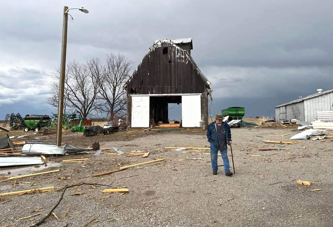
One tornado touched down at 5:06 p.m. east of the Sugar Bottom campground and tracked northeast toward Solon. A radio tower was destroyed and a home sustained roof damage The tornado continued on a northeasterly track before destroying a machine shed at the Richard and Judy Miller farm on Racine Avenue. According to the NWS Quad Cities, debris from the Miller farm was lofted into a field with a 2×4 driven into the ground.
“It appears this is the second time that a tornado has hit that exact location,” said Jodi Miller Palmer. “Dad (Richard) thinks there was one back around 1983 when my uncle, Earl Miller, lived on the property.” The shed that was destroyed, she said, was built less than six months ago.
The tornado continued into the city of Solon uprooting trees, bending street signs and ripping the roof off of the Solon Hardware Store and El Sol Mexican Restaurant.
KCRG TV9’s Solon CityCAMs captured the tornado crossing Main Street and peeling off the roof during the station’s live “wall-to-wall” weather coverage. No injuries were reported with this tornado and the Solon Fire Department assisted an elderly resident from her apartment above the hardware store. Firefighters also worked to cover the damaged roof with tarps.
The storm, initially estimated at EF-3 strength, was rated EF-2 with 125 mph winds along a 4.4-mile path with a maximum width of 50 yards. The storm dissipated and lifted just north of Sutliff Road after being on the ground for five minutes. No injuries or fatalities were reported with this storm.
Nearly simultaneously, a second tornado developed approximately one mile west-northwest of Solon damaging the roof and windows of a home in the new Trail Ridge Estates housing development. It traveled eight miles, destroying two large outbuildings and grain silos at the Stahle farm on 140th St. This tornado also snapped or uprooted several trees and downed powerlines during the eleven minutes it was on the ground. This tornado was also rated as EF-2 with 130 mph winds and a 75-yard maximum width. Again, no injuries or fatalities were reported.
In Johnson County, the Joint Emergency Communications Center (JECC) received 118 calls for service directly related to tornado activity through 7:30 a.m. the following morning. With multiple calls for powerlines down, trees down on buildings, collapsed buildings, gas leaks, etc., the Swisher Fire Department was called to assist Solon firefighters.
The day after, and beyond
The next morning, teams from NWS Quad Cities began surveying the damage from the storms.
Justin Schultz, Lead Meteorologist, explained how the surveys are conducted.
“We send out survey teams, usually two people, and we investigate the damage. Initially, we look for potential tornadoes based on what we see on our radar imagery and damage reports and determine locations to begin the survey. We will then look for any damage and try to see how far the damage goes in either direction, determining the path length. In terms of path width, we gauge this by looking at the width of the swath of damage. As we perform the survey, we take photographs of the damage, along with the location of the damage. If structures were damaged, we attempt to determine how well built the structures were. We continue to survey until we see no more damage, which is a good indicator of the end of the tornado path. Then, we synthesize all of the information to determine the path length, width, and rating of the tornado based on the damage we see.”
NWS Quad Cities has on their website a comprehensive listing of storm reports, damage surveys, and maps showing the approximate track and details for each tornado at https://www.weather.gov/dvn/summary 03312023. The page will be updated until all surveys are completed.
City of Solon
Residents of Solon are asked to contact City Hall at 319-624-3755 or email [email protected] if their property was damaged. The City Building Inspector began conducting damage inspections Monday, April 3 and Public Works began curbside pickup of tree debris as well.
Storm debris can be taken to the City Shop at 1031 Stinocher St. A roll-off container is placed by the salt storage building for construction-type debris. Tree debris can also be taken to the City Shop location.
Please contact City Hall with any storm related questions, needs, or concerns.
Johnson County residents affected by severe weather outbreak encouraged to self-report property damage.
Johnson County Emergency Management is encouraging individuals who were affected by the severe weather outbreak to self-report property damage.
Property damage can be self-reported at https://www.crisistrack.com/public/johnsonIA/request.html. This is the first step for potential individual assistance through the State of Iowa.
Aftermath and ways to help
Saturday, April 1, Governor Kim Reynolds issued a Disaster Proclamation for twelve counties in Eastern Iowa – Cedar, Clinton, Delaware, Des Moines, Dubuque, Grundy, Johnson, Keokuk, Linn, Mahaska, Wapello, and Washington. The proclamation allowed state resources, such as trucks and equipment operated by the Iowa Dept. of Transportation, to be utilized in clean up and recovery efforts. In addition, the proclamation activated the Iowa Individual Assistance Grant Program for qualifying residents, along with the Disaster Case Management Program for the affected counties.
The Iowa Individual Assistance Grant Program provides grants of up to $5,000 for households with incomes up to 200% of the federal poverty level. Grants are available for home or car repairs, replacement of clothing or food, and temporary housing expenses. Original receipts are required for those seeking reimbursement for actual expenses related to storm recovery. The grant application and instructions are available at https://dhs.iowa.gov/disaster-assistance-programs. Potential applicants have 45 days from the date of the proclamation to submit a claim.
The Disaster Case Management Program addresses serious needs related to disaster-related hardship, injury, or adverse conditions. Disaster case managers work with clients to create a disaster recovery plan and provide guidance, advice, and referral to obtain a service or resource. There are no income eligibility requirements for this program. It closes 180 days from the date of the Governor’s proclamation. For information on the Disaster Case Management Program, contact your local community action association or visit www.iowacommunityaction.org.
United Way of Johnson and Washington Counties is responding locally by helping individuals and families who are facing losses from the storm. United Way’s 2-1-1 service has been, and continues to be, available for those in need of assistance due to the storm. 2-1-1 is a free, 24/7 hotline that provides information to individuals seeking community resources. Those in need of immediate assistance may access support services by dialing 2-1-1 on their cell, texting their zip code to 898211, visiting 211iowa.org, or downloading the 211 Iowa app.
If you would like to donate to the United Way of Johnson and Washington Counties Community Disaster Fund, visit https://www.unitedwayjwc.org/civicrm/contribute/transact?reset=1&id=1.
The Community Foundation of Johnson County has an established emergency response fund that provides funding to Johnson County nonprofits working directly with individuals to address immediate and emergent needs. Individuals who would like to contribute can do so at https://cfjc.fcsuite.com/erp/donate/create/fund?funit_id=1393.
Damaged machinery sits in the remains of a shed after a tornado blew through the Richard and Judy Miller farm on Racine Ave. Friday, March 31. The storm was initially rated as an EF-3 tornado but was ultimately determined to be an EF-2 with 125 mph winds.


